Using shaded relief to look at the “grain” of the landscape
or “Lineament Analysis”
Use hillshading from different perspectives to highlight features of different orientation.
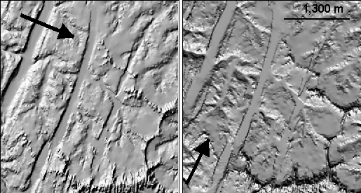
Here’s a look at part of the Colorado Plateau with NE-SW fault zones, but is there more….?
The left side is illuminated from the NW (315) and the right is from the SW (195)
try it on the DEM in demo/topo
Perspective ?
How do create a sense of looking at a real 3D image?
- atmospheric effects
- reflection or haze (scattering)
- illumination of “dark” shadows with reflection or haze
- clouds? skyline? tree line?
Type “terrain visualization” into Google and you’ll see what I mean.