Electromagnetic waves –
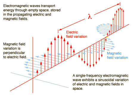
from http://hyperphysics.phy-astr.gsu.edu/hbase/emwav.html
electromagnetic spectrum –
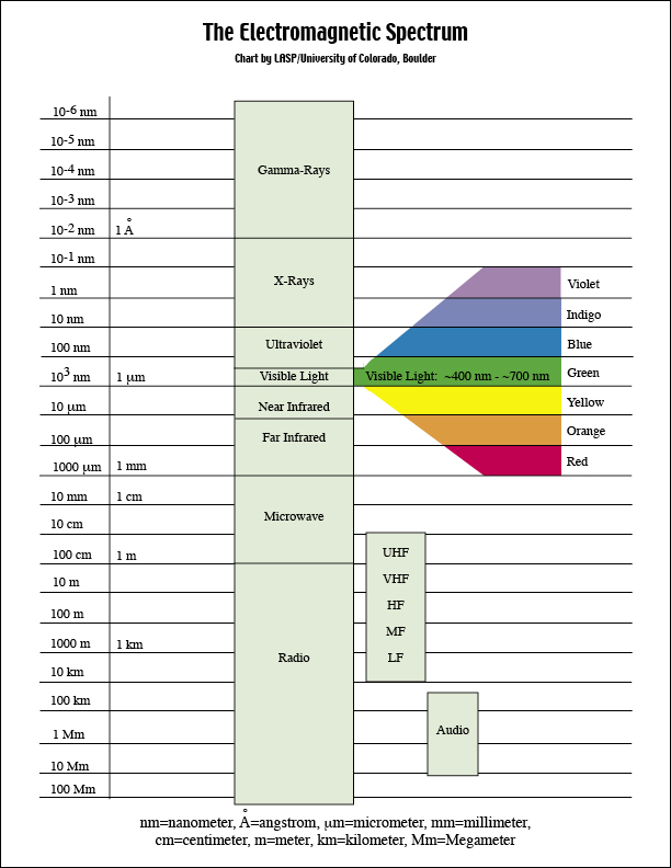
http://lasp.colorado.edu/cassini/education/Electromagnetic%20Spectrum.htm
The energy used in remote sensing of the earth comes from the sun. When solar energy strikes an object or molecules of the atmosphere/hydrosphere, many types of interaction are possible. The energy is:
- Transmitted & refracted. The energy passes through with a change of velocity as determined by the index of refraction for the two media and the wavelength. (Pencil in water?)
- Absorbed. The energy is given up to the object through electron or molecular reactions.
- Reflected. The energy is returned unchanged with the angle of incidence equal to the angle of reflection. Reflectance is the ratio of reflected energy to that incident on a body. For visible light, the wavelength(s) reflected (not absorbed) determines the color of an object.
- Scattered The direction of energy propagation is randomly changed. Rayleigh and Mie scatter are the two most important types of of scatter in the atmosphere.
- Emitted. When energy is absorbed, some of it is re-emitted, at longer wavelengths for cooler objects. The object heats up with increasing stored energy.
What’s the difference in the sky in the first two photos? What’s the difference in shadows in the second two photos?


credits: http://geology.wlu.edu/ (Chris Connors) & http://history.nasa.gov/ap11ann/kippsphotos/apollo.html & https://www.scottramsey.co.uk/blog/2013/12/29/light-and-shadow-photography-on-boxing-day
Scattering in Earth’s atmosphere http://hyperphysics.phy-astr.gsu.edu/Hbase/atmos/blusky.html#c4
The atmosphere plays a large role in remote sensing results ( think about the “greenhouse effect”)
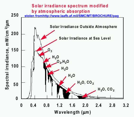
Question for ya: Given the above graph, what is the relationship between total energy received and the development of “visible” light detection in human eyes?

http://www.astro.utu.fi/kurssit/ttpk1/ttpkI/18Maailmankaikkeus.html
A Quiz . . . . .
Given that different satellite sensors “see” using different parts of the EM spectrum (as above) . . . . . would you use a visible light sensor or radar sensor to map river floodwater extent in the Amazon rainforest throughout the seasons?
Answer
Visible light region http://www.satnews.com/cgi-bin/display_image.cgi?119887795
or
Radar region www.esa.int