Your goal for this project is to develop the beginnings of a landslide hazard assessment for the mountain front of the Blue Ridge. We’ll add to the complexity in the next project. The first two steps taken during this project are to 1) produce a model that maps watersheds and streams from field GPS data that give the outlets of major basins, and 2) create a landslide hazard assessment model based on slope and aspect. For the latter, I am not expecting you to be an expert on landslides, but you need to be a reasonable GIS manager given the expert opinions below. For extra credit (+5), you can evaluate the hazard downstream from each of the mapped basin outlets based on people or structures at risk in and near the waterways.
The input data are the GPS points for an area from Buena Vista downstream along the Maury River (in Word document) and the study area outline (shapefile), both available in the project two folder in the box\2024GIS\sharedwork\projects folder. DEM data are available from the USGS (3D Elevation Program at the National Map). At the USGS download application, zoom in here,

then download the 1 arc-second data – not anything finer: don’t get 1/3 second or lidar. The DEM data must be further clipped to an area near the study area, and they must be projected. Please consider removing your downloaded data once you’ve clipped and projected the data you need to eliminate online storage. Don’t forget to update your metadata (where you got it, what you did to project the data and limit it to the area near the study area).
Construct two geoprocessing models, one that creates stream and watershed maps for basins in the input data, and another that assesses the landslide hazard using the DEM. A goal in making these models is that they could be a tool in other areas; given a new outlets, study area and DEM, your analysis could be applied by our neighbors in Nelson and Amherst counties, for example. Please label elements of your model that need explanation (e.g., raster calculator equations). Ask Dave to show you how to make labels if you don’t know how. All processes can be done on the model for the highest score, but if you need to do some off-model to save time or frustration, that works for a “good” model.
If you turn your model into a tool using element names, parameters and metadata, you can collect an extra 5 points. ESRI has a “quick start tutorial” that shows you how, if you want to learn that way.
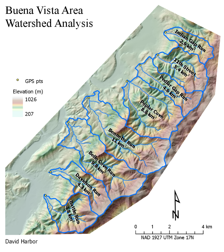
The watershed/stream model should have a variable that allows the user to input the drainage area in km-squared where stream channels initiate (start with 0.1 km-squared in this case). For output, streams should be clipped to the basins above the GPS points. Caution: ArcGIS may create multiple watershed polygons from one raster basin when you convert raster to vector. These one- to few-cell basins near the outlet should be eliminated (in the model preferably). The result should be an 8.5 x 11 layout exported to pdf that looks something like this but you might want to use the datum of the DEM instead of the one I used, right?
The landslide hazard model should be completed within the study area only and incorporate the knowledge of our local expert, who suggests that slopes above 25 degrees become increasingly hazardous, especially on north-facing slopes where soils remain wet longer. You choose the way to incorporate this information into the overlay model and how much control of model output is governed by user input. A gradational result is preferred over a binary one, and slope should not be considered the same as aspect (e. g., a north-facing gentle slope is less hazardous than a south-facing steep slope). On a second 8.5×11 layout, display and/or analyze the hazard model results within the documented watersheds by area and/or degree of hazard. Place on the layout a brief explanation of the hazard model criteria and results to a layperson (use the text rectangle tool from the insert tab on the layout menu).
You need to build metadata for the following data files (from the catalog) and well-named maps (Catalog or TOC properties box).
-
- your GPS points data file (how it came to be a point file in your gdb)
- projected and clipped DEM data (what needed to happen to get it to your gdb)
- watershed and stream data (simple; refer to the stream/basin model)
- The hazard data (again, refer to the model that created it).
- the stream and basin map (brief statements of how above data layers were displayed)
- landslide hazard map
Use my map composition suggestions when you build your layouts. You may choose to seek out other good sources for how to build clear, informative maps.
Post the following to the Assignment discussion by the deadline
– do not edit after submitting please–submit changes to me directly
– one post per group is fine
-
- Names of the people working on the project
- An exported PNG of the watershed/stream layout
- A exported PNG of the watershed/stream model
- An exported PNG of the landslide hazard layout
- An exported PNG of the landslide hazard model
Post the following information on a document to the Assignment:
-
- The names of people working together (one submission per group is fine)
- The location of the completed ArcGIS project on geodata or in box (Path & Filename from the Options box in ArcGIS Pro).
- a snip of the catalog showing the geodatabase and toolbox elements
- a brief explanation and justification of how the model hazard was calculated.
- Snips of the requested metadata as seen from the TOC properties box of each data layer or map (but remember that’s not where you input data metadata–do so from the Catalog View)
- Extra Credits:
- for the downstream hazard.
- A layout displaying the results with a text box containing a brief explanation of your method.
- Model-to-tool conversion;
- snip of the model as opened in geoprocessing
- snips of the “information” tip that comes from the metadata, for the tool itself and one of the input boxes.
- for the downstream hazard.